
Breakthrough cloud-free satellite imaging data combined with expert human analysis enables utilities companies to understand trends, predict risks and make more informed decisions.
Earth observation data is increasingly relied upon for critical intelligence by utilities organisations, insurers and many more sectors. But earth observation imaging from satellites is currently hampered by clouds and intelligence is lost during each period of cloud cover.
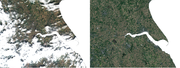
Aspia Space has launched a cutting-edge solution that sees through clouds. Its new service will provide organisations with accurate, rapid, regular, cloud-free high-resolution images of the ground almost anywhere in the world, from entire countries down to a pixel scale of 10m.
Aspia Space brings together its breakthrough technology with expert human eye analysis by its team of scientists to provide organisations with enhanced intelligence about changes to the ground over time, from days, weeks, months or years.
This will enable utilities and water management organisations to see both the big picture and finer details with accuracy, identify and understand trends, detect flooding issues and predict risks and make faster, more informed decisions.
Its unique patented algorithm combines AI and cloud-penetrating Synthetic Aperture Radar (SAR) Earth observation data to predict detailed multispectral satellite imagery of the ground, from flood plains to farmland to mountain ranges, even in the presence of 100% cloud cover.
Jim Geach, co-founder of Aspia Space, commented: “Our service unlocks Earth observation imaging data and intelligence that would have otherwise been lost. By bringing together advances in satellite imaging and machine learning, as well as a deep knowledge of how to analyse and interpret data, we can offer organisations unprecedented cloud-free Earth observation imaging and understanding of the conditions and trends on the ground, across multiple sites, anywhere in the world. This hands them the opportunity to predict flooding, react to events and manage resources more effectively.”

